
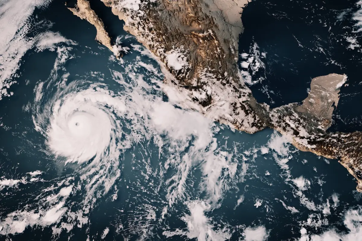
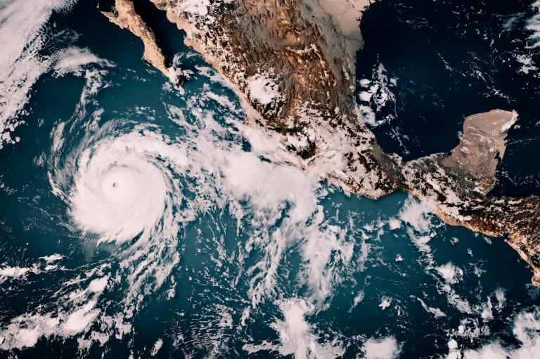
A powerful climate phenomenon is surging across the Pacific Ocean, injecting an extraordinary amount of energy into the atmosphere and fundamentally altering weather patterns worldwide. El Niño, a natural cycle in which a band of warm water forms every three to five years off the coast of South America, raises ocean temperatures by just a few degrees for a typical duration of nine to 12 months. However, the current event has already broken records as the strongest El Niño ever documented, and climate scientists warn that it may not peak for another month or two.
Climate scientists emphasize that even minor shifts in ocean surface temperatures carry massive consequences for the global atmosphere. Because the ocean has an immense capacity to hold heat—possessing roughly 1,000 times more thermal storage capability than the air above it—small changes near the surface can dramatically drive atmospheric circulation. While researchers continue to study how global climate change may be intensifying El Niño cycles, the current event offers a stark preview of what default planetary conditions could resemble in the coming decades as baseline global temperatures continue to rise.
The fallout from this colossal climate driver is projected to be both global and severe. Scientific models estimate that the extra heat alone could contribute to around 450,000 deaths worldwide. The phenomenon is already locking critical ecosystems, such as the Amazon rainforest, into dangerous droughts, while unleashing torrential, catastrophic rainfall in regions like the Greater Horn of Africa. Furthermore, interactions between El Niño and the stratospheric polar vortex—which periodically sends blasts of frigid air across North America—are scrambling atmospheric conditions even further, promising an unpredictable and hazardous season across multiple continents.
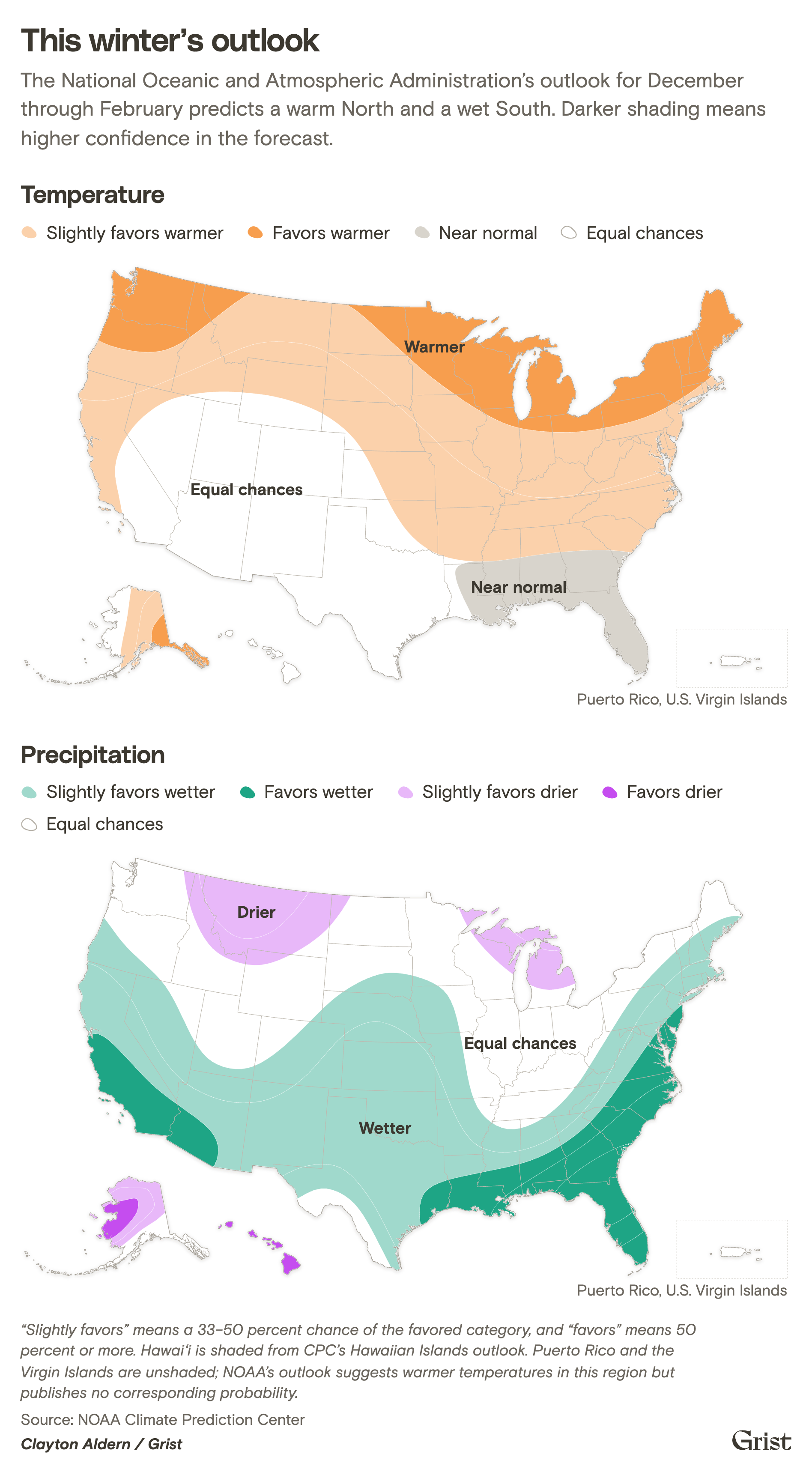
As the weather shifts unpredictably, federal and state agencies across the United States are bracing for vastly different regional impacts. Government forecasters predict a warm North and a wet South, though the exact manifestation of these trends varies sharply from coast to coast.
Alaska
Alaska, home to America’s largest expanses of Arctic territory, remains uniquely vulnerable to rapid climate shifts. The state is warming several times faster than the global average, and a strong El Niño adds a significant layer of short-term thermal stress on top of that long-term trajectory.
Typically, a powerful El Niño strengthens the Aleutian Low, a massive area of low-pressure air over the North Pacific that dictates winter conditions across the state. Because multiple atmospheric factors influence this low-pressure system, predicting exact outcomes in Alaska remains challenging. State climatologists advise caution, noting that while populated regions along the Gulf of Alaska and the southeast may see warmer winter temperatures and rain instead of snow, the overall historical trend during strong El Niño years points toward below-average snowfall.
Any pattern that accelerates local warming compounds existing environmental crises in Alaska. Melting sea ice leaves shorelines exposed to severe storm erosion, while thawing permafrost causes land to collapse. Simultaneously, warmer coastal waters threaten traditional fisheries and trigger harmful algae blooms, placing additional pressure on communities that have relied on these marine ecosystems for generations.
Hawaiʻi and the Pacific Islands
Hawaiʻi and the broader Pacific region have already endured a destructive year, marked by summer and fall storms, severe flooding, prolonged power outages, and landfalling typhoons in the western Pacific.
In the months ahead, Pacific islands face the dual threat of drier conditions and powerful storms. The National Oceanic and Atmospheric Administration warns that Guam and the Commonwealth of the Northern Mariana Islands face an above-normal typhoon season, building on an already volatile period. Meanwhile, Hawaiʻi faces a drier-than-average wet season, which typically runs from October through March.
While a historically wet summer has left the landscape lush with vegetation, the oncoming dryness threatens to turn that growth into tinder, significantly elevating wildfire risks. Climatologists note that historical patterns often indicate the worst drought impacts materialize the year following El Niño’s initial onset, suggesting severe environmental stress could persist well into future months.
Midwest
The Midwest may experience a brief reprieve from bitter cold as El Niño peaks this winter. The cyclical pattern typically shifts the polar jet stream farther north, reducing the likelihood that Arctic air masses will plunge deep into the region.
While winter storms and snow remain possible, average temperatures between December and February tend to trend significantly higher. During past strong El Niño events, winter temperatures in the region ranged from 3 degrees Fahrenheit to more than 8 degrees Fahrenheit above historical averages. This warmth follows a record-setting warm autumn across several Midwestern states.
Reduced ice cover on the Great Lakes is expected to allow stored summer heat to dissipate slowly into the surrounding atmosphere, impacting local winter recreation and lake ecosystems. Conversely, climate scientists suggest the region could experience a quieter tornado season in the spring, as severe weather tracks further south into states like Arkansas and Georgia.
Northeast
The Northeast has largely avoided the immediate disruptions of the current El Niño, but forecasters warn that conditions are poised to shift. Extended weather predictions point to a greater than 50 percent chance of a milder-than-normal winter across the region, accompanied by variable precipitation levels.
While private forecasting models predict fewer overall snow accumulations, meteorologists caution that a wetter atmosphere increases the risk of high-impact winter storms, particularly along the heavily populated I-95 corridor between New York and Boston. Even when precipitation falls as rain rather than snow, urban planners are advised to prepare for localized flooding and hazardous road conditions resulting from fluctuating rain, ice, and melting snow.
Northern Great Plains
Forecasters face higher uncertainty when predicting El Niño impacts across the Northern Great Plains. States like Nebraska, Montana, and the Dakotas anticipate a warmer-than-average winter, but precipitation forecasts remain inconclusive.
Eastern Nebraska has experienced milder autumn temperatures and heavy rains leading to flash flooding, a pattern that could persist through the winter months. In South Dakota, agricultural experts note that a snowy winter would help alleviate lingering drought and reduce wildfire risks in the Black Hills, whereas a dry winter could accelerate drought pressures by spring. Montana faces a similar split; historical data from past strong El Niño events shows a nearly even split between below-normal and above-normal snowpack, leaving agricultural producers uncertain about future soil moisture levels.
Northwest
The Pacific Northwest typically relies on a steady stream of cool, wet winter storms tracking inland from the Pacific Ocean. El Niño disrupts this pattern by steering the storm track southward toward California, frequently leaving the Northwest warmer and drier than usual.
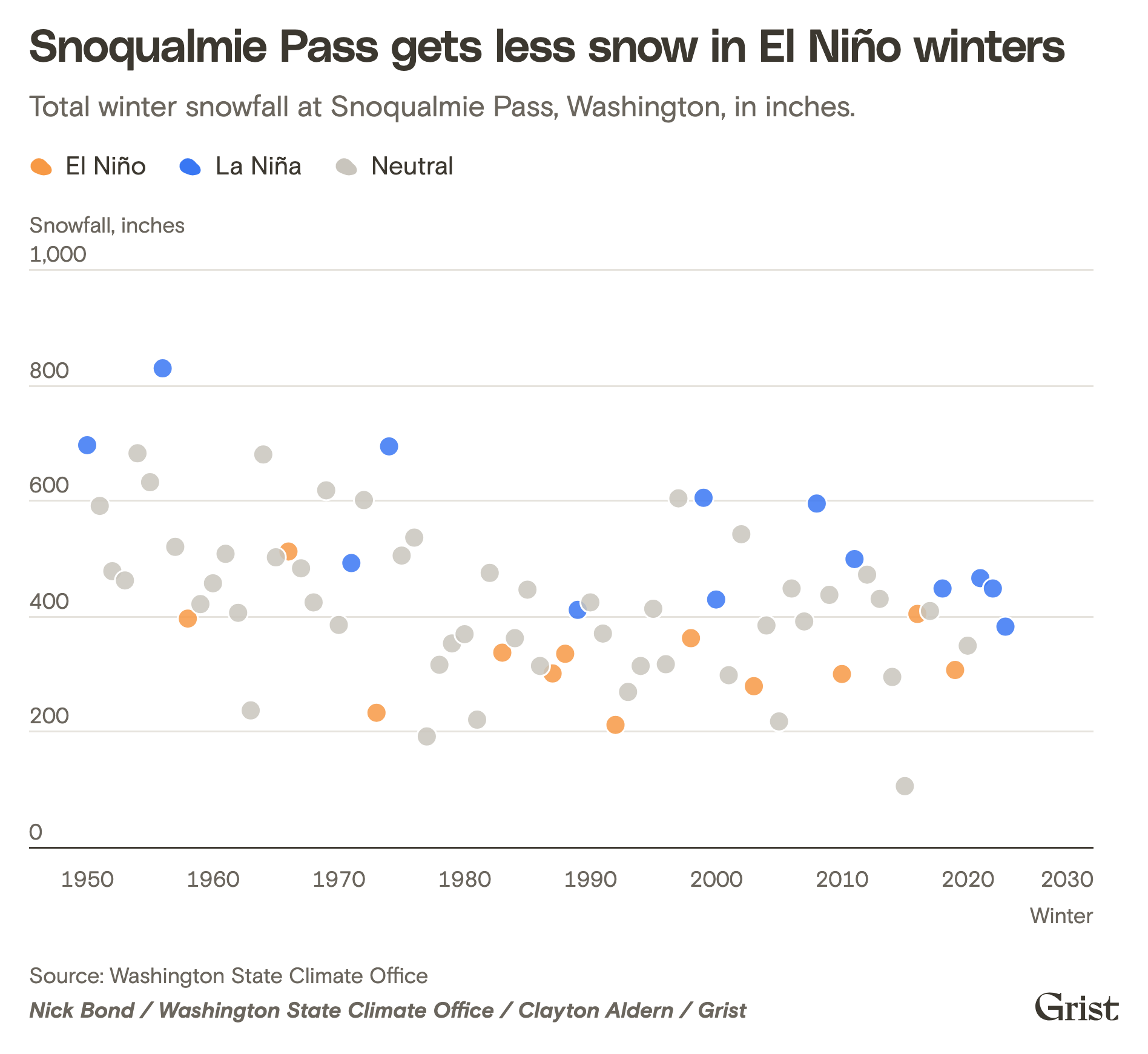
This combination poses a significant risk to mountain snowpack, which serves as the primary water supply for the region. Reduced snow accumulation can exacerbate summer drought conditions, restrict hydropower generation, and elevate wildfire risks. Additionally, coastal communities face an increased threat of tidal flooding, as shifted wind and ocean patterns raise high tide levels by several inches, compounding the long-term risks of sea level rise and winter storm surges.
Southwest
The Southwest stands to benefit from potential moisture delivered by El Niño, offering a glimmer of hope to a region gripped by historic drought. Climatologists anticipate favorable storm activity across desert areas in Arizona and New Mexico, with effects reaching Nevada and parts of southern Utah and Colorado.

However, northern Utah and parts of Colorado remain difficult to forecast precisely. Despite potential relief, experts emphasize that a single wet winter cannot permanently resolve deep-seated water deficits in major reservoirs like Lake Mead and Lake Powell, nor can it fully restore the declining water levels of the Great Salt Lake. Extreme hydrological swings between extended dryness and sudden torrential downpours are expected to become increasingly common as global temperatures rise.
Southeast and the U.S. Caribbean Islands
For the Southeastern United States, El Niño typically ushers in a wetter pattern accompanied by potential bouts of severe cold weather. Moist air streaming eastward from California often interacts with Arctic air masses, creating conditions ripe for damaging ice storms, slick roads, and extended power outages in a region unaccustomed to prolonged freezing temperatures.
At the same time, the incoming rainfall provides critical relief to parts of the region that suffered through record-breaking droughts and destructive wildfires over the past year. Furthermore, El Niño provides a silver lining by suppressing the formation of Atlantic hurricanes, reducing widespread tropical storm threats for much of the region, though areas like South Florida and the Bahamas remain exceptions to this trend.
Southern Great Plains
The Southern Great Plains are bracing for potential heavy rainfall that could offer much-needed relief from persistent drought conditions. State agencies and industrial operators in Texas have issued severe weather advisories, warning that the magnitude of the upcoming event could exceed historical baselines.
While increased moisture will aid agricultural sectors depending on timing, hydrologists caution that depleted deep aquifers will require years of sustained precipitation to return to normal levels. In Kansas, regional impacts remain less certain, though historical data from past strong El Niño cycles suggests an increased probability of above-average precipitation stretching from autumn through early spring.
California
California faces the dual threat of receiving far more water than existing municipal infrastructure can efficiently manage. Winter forecasts warn of atmospheric rivers capable of dumping torrential rain, overwhelming urban wastewater systems, flooding agricultural lands in the Central Valley, and piling dangerous amounts of snow into the Sierra Nevada mountains. Governor Gavin Newsom previously declared a state of emergency to bolster preparedness against severe coastal flooding, erosion, and extreme storms.
Cities and state agencies have invested heavily in proactive mitigation, deploying "sponge" infrastructure such as roadside bioswales and partnering with agricultural districts to divert excess runoff into open basins to recharge vital groundwater aquifers. Despite these measures, climatologists caution that extreme rainfall can paradoxically fuel future disasters. Copious winter moisture stimulates heavy vegetation growth, which subsequently dries out during the summer heat, transforming the landscape into tinder and raising the threat of catastrophic wildfires during autumn wind seasons.